
RECORDER Manual
| |
|
|
The GPS option allows to attach any GPS receiver complying with the NMEA 0183 protocol (either a Bluetooth GPS receiver, a USB GPS mouse or a handheld GPS unit) to the PC in order to simultaneously acquire the associate geographic locations of the recorded .wav files. The collected geographic coordinates are saved into the .wav file header, the ASCII-formatted RECORDER LOG file and optionally into common .gpx or .kml files that can be imported into GIS applications such as Google Earth.
The GPS Settings dialog box can alternatively be launched by right-clicking at the Avisoft-RECORDER GPS status window.
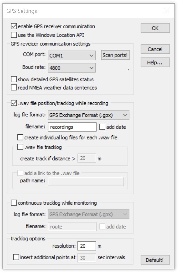
enable GPS receiver communication : Activate this option in order to enable the serial communication with the GPS receiver. If activated, the Avisoft-RECORDER GPS status window will be launched. This window displays the current GPS coordinates, the current date and the local time:
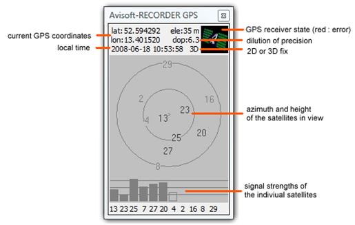
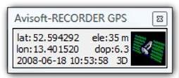
The Avisoft-RECORDER GPS status window can be minimized (right) or enlarged (left) by left-clicking at it.
If activated, the option use the Windows Location API will retrieve the location data directly from Windows Location API rather than reading the information through a (virtual) COM port. This requires at least Windows 7 and a GPS receiver that supports the Location API. Use this option on Windows 8 / 8.1 / 10 tablet computers with inbuilt GPS.
GPS receiver communication settings
The communication with the GPS receiver takes place through a (virtual) serial COM port of the PC, which must be identified here. Note that Bluetooth and USB-based GPS receivers also communicate with the PC via a virtual COM port (they therefore require to install an appropriate USB-to-Serial Com Port driver).
COM port : If the com port number is already known (for instance from the Windows Device Manager), then select here the port number to which the GPS receiver is connected.
Boud rate : Select here the boud rate at which the GPS receiver sends its data. This information can be found on the manual or specification sheet of the GPS receiver.
Scan ports! : If either the COM port number or the boud rate is unknown, use this button for detecting the proper COM port settings for the GPS receiver automatically. Depending on the number of available COM ports, this procedure can take up to several minutes.
show detailed GPS satellites status : This option activates the satellites status display that indicates the signal strengths of the currently used satellites. This display option can also be toggled by left-clicking at the Avisoft-RECORDER GPS status window.
read NMEA weather data sentences: This option will additionally parse NMEA weather data sentences that are provided by a number of GPS receivers. Currently supported are the Airmar/Furuno PBxxx/LBxxx WeatherStations ($WIMDA) and Navilock NL-120GR / Wintec WSG-1000 ($IISMD) GPS receivers. If this option has been activated, the Weather Station Settings dialog box will be launched afterwards, which allows to select the measurements to be logged. The dXML metadata input settings dialog will then activated the corresponding dXML date fields. In order to get both the weather and GPS data from the Airmar weather station devices, only the following NMEA sentences should be activated: GSA, GSV, MDA, RMC (GGA, which provides the elevation must be disabled in order to satisfy the bandwidth constraints).
.wav file position/tracklog while recording
This option will additionally save the GPS positions of the recorded .wav files into separate log files.
log file format : Chose either the GPX Exchange Format (.gpx), the Google Earth Format (.kml) (also referred to as Keyhole Markup Language) or the ESRI Shapefile Format (.shp including .shx, .dbf, prj). The shapefile option will also save the optional dXML data set (including weather data).
filename : Enter here the filename of the recording log file. The path name for the log file is always the Base directory selected from the RECORDER Configuration dialog box.
add date : This option will append the current date to the filename.
create individual log files for each .wav file : If this option is activated, an individual ..gpx/.kml log file will be created for each recorded .wav file. The log file name will then be derived from the corresponding .wav file name (same path and filename, except of the file type extension).
.wav file tracklog : This option will create a track representing the path of the .wav file if the distance moved from the start until the end of the sound file is longer than the threshold specified on the following option:
Create track if distance > xxx m : If the distance moved from the start until the end of a sound file is shorter than this threshold, no track entry will be created. Enter here a distance that is longer than the current GPS position variation in order to prevent generating undesired track entries in the log file while the microphone position is actually fixed.
add a link to the .wav file : If activated, this option will add a direct link (href=C:\Users\
\T00001.wav) to the .wav file into the waypoint data tag (only available for .kml files). An alternative pathname can be defined from the path name edit field. The local pathname of the recording computer will then be replaced by this string (it can also be an URL pointing to a website).
Continuous tracklog while monitoring
This section allows to specify whether an additional log file should be created for complete monitoring sessions. Use this option for surveys in which the .wav files are being recorded in a trigger mode. In this way it is possible to document the path moved while no sound file was being recorded.
log file format: Select here the log file formats .gpx, .kml, .shp or .txt. The last option NMEA 0183 Format (*.txt) saves the original NMEA data stream as received from the GPS receiver. The shapefile option will also save the optional dXML data set (including weather data). Kml files can be created either with the conventional format (that does not include time stamps) or alternatively with the more recent MultiTrack format that is support in Google Earth 5.2 or later.
filename : Enter here the filename of the monitoring log file. The path name for the log file is always the Base directory selected from the RECORDER Configuration dialog box.
add date : This option will append the current date to the filename.
tracklog options
resolution xxx m : The specified distance determines the resolution of the created tracklogs. Each time the current GPS position has changed at least by this amount, a new track point entry will be added to the log file. Smaller values will create larger log files.
insert additional points at xxx sec intervals : If activated, this option will add additional waypoints to the tracklog at the specified time interval. Use this option for an easier navigation through .wav files that have been recorded on the move (on the .wav file tracklog) or to create regular samples on the continuous tracklog file.
Default! : The default button resets all settings to their defaults.
In case the Create bext .wav file header chunk option has been activated the from File Name Option dialog box, the GPS position data data will also be saved into bext .wav file chunk.
|
|