
SASLab Manual
| |
Main window : Tools > Labels > Georeference labels
|
|
This tool looks up the geographic coordinates of the labels that have been added to a sound file that was recorded by the Avisoft-RECORDER software. In field survey applications, it is for instance possible to display the identified species on a map.
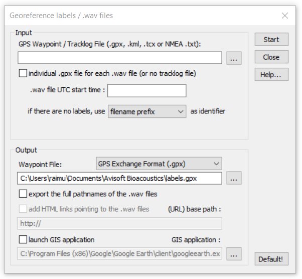
If there are no labels stored in the .wav file, the program can instead use different identifiers that apply to the entire .wav file. The available options can be selected from the list box titled if there are no labels use xxx as identifier:
filname prefix The program searches for filename prefixes (separated by space or underline characters such as ‘Ppip T0001.wav’) that have been created for instance by using the command File/Rename and will use these strings as species references.
dXML field A specific dXML data field (for instance “species”) is being used as an identifier for the waypoints to be created. The corresponding name of the dXML field must then be entered.
Fixed string A fixed user-defined string is being used as identifier for the waypoints. This option can be used for batch processing of (short) stationary files.
The GPS time stamp information that is saved in the recorded .wav files is used to look up the geographic coordinates from a .gpx or NMEA tracklog file (note that .kml tracklog files do not work because they do not contain the required time stamps). Alternatively, the UTC start time of the sound file can be entered manually. The results containing the label name, the associated coordinates and the time stamp can be saved into a .gpx, .kml, .shp or .txt file.
Input
GPS Waypoint / Tracklog File (.gpx, .kml, tcx or NMEA .txt)
Select here the tracklog file from which the time stamps and GPS coordinates should be taken. Supported file formats are the GPS exchange format (.gpx), Google Earth (.kml with MultiTrack entries), Gamin Trainings Center (.tcx) and NMEA 0183 formatted text log files (.txt). This would be normally the continuous tracklog file created by the RECORDER software (Options > GPS Settings... > continuous tracklog while monitoring).
individual .gpx file for each .wav file (or no tracklog file)
If the RECORDER software was configured to create individual log files for each .wav file and the .wav file tracklog option was activated, it is possible to use the tracklog information from these individual files by activating this option.
Stationary sound files (that were recorded at a fixed place) do not require a separate tracklog file because the fixed GPS coordinates will be taken directly from the .wav file header (activate the option individual .gpx file for each .wav file (or no tracklog file) in this case).
.wav file UTC start time
This edit field should display the UTC start time that is stored in the file header of the .wav file. This information is saved by the RECORDER software, version 3.4, dated 14 January 2009 or later. If the UTC start time stamp is not available, it is also possible to enter that time manually (format: yyyy-mm-ddThh:mm:ssZ).
Output
Waypoint File
Enter here the destination .gpx, .kml, .shp or .txt file name into which the results should be written. The .gpx, .kml and .shp format options comply with the industry standard and can be viewed in various GIS applications. The .txt format is a simple TAB-delimited ASCII table that contains the label names, the time stamps and the geographic coordinates.
This command can also be executed on several sound files at once by using the associated batch command option (Tools > Batch processing...).
export the full pathname of the .wav files
If this option is activated, the complete local pathnames of the .wav files will be added to the resulting output file (only available with .kml files).
add HTML links pointing to the .wav files
This edit field allows to replace the original (local) pathname of the .wav files in the resulting .kml file by a user-defined URL, which can simplify publishing results on Google Maps for instance. Note that the pathnames could also be replaced afterwards in a word processor application.
launch GIS application
If activated, the program will run the specified GIS (Geographic Information System) application with the resulting .gpx/.kml file as a command line argument. One possible program would be GoogleEarth, which can (in the current version 5.1) however only open .kml files as a command line argument. Gpx files must be instead opened separately.
|
|