
SASLab Manual
| |
Main window : Metadata > Metabase GPX / KML / SHP Export
|
|
The Metabase GPX / KML / SHP (GIS) Export tool allows exporting selected data fields of the metabase table into a .gpx or .kml file or the entire matabase into a shapefile.
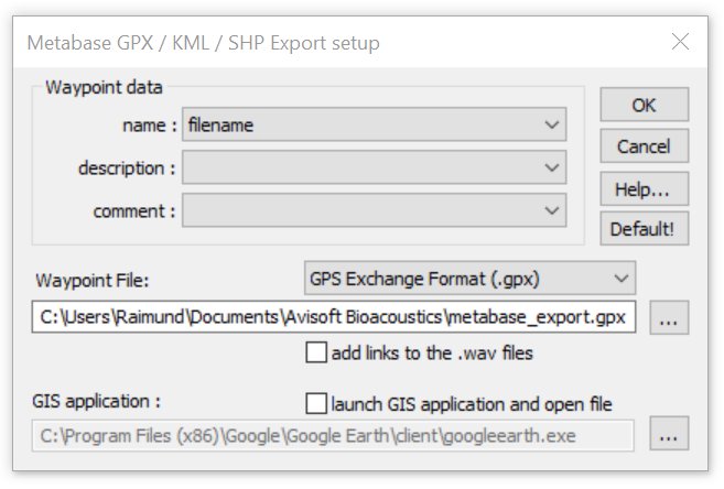
Waypoint data
name Select here the metabase field that should be assigned to the tag of the .gpx file.
comment Select here the metabase field that should be assigned to the tag of the .gpx file.
description Select here the metabase field that should be assigned to the tag of the .gpx file. This option is only available on the .gpx format.
Icons based on Select here the .kml name or description field in order to assign different icons for each string. If there has been defined a picklist on the dXML tool for the corresponding dXML field, the order (color) of the icons will be fixed. In this way it is for instance possible to create maps with different icons for each species. This option is only available on the .kml format.
Select the empty line in case the specific .gpx/.kml tag should not be created. In case there are multiple data records associated to a single .wav file (such as multiple species names for instance), make sure to activate the expand option on the Metabase window in order to create waypoint for each of these additional data records.
Waypoint File Enter here the name of the .gpx / .kml / .shp waypoint file to be created. Use the
button to browse to a specific folder.
add links to the .wav files If activated, direct links (full path) to the .wav files will be added to each waypoint.
launch GIS application If activated the created .gpx will be opened by the specified GIS application (using a command line parameter) that has been selected below. Note that only .kml files can be opened this way in GoogleEarth.
Click at OK to create the waypoint file.
|
|